Canal building between 1825 and 1848 opened Ohio to new markets and new settlers. The settlers cleared the land and harvested bountiful crops with no efficient, economical way of transporting the produce, lumber, and goods to markets in the east. For 25 years the canals were the principal means of moving people and freight in Ohio. The canals reached the height of their influence between 1827 and 1850. The two main trunks of Ohio's canal system were the Ohio & Erie and the Miami & Erie but the canal which passed through Newton Township was part of an almost privately built "feeder canal" called the Pennsylvania & Ohio. Sometimes called the Mahoning or the Cross-Cut Canal, this proved to be one of the more successful feeder canals.
Three routes were actually considered for the path of the canal, but after years of political meetings, a group of Ohio and Pennsylvania businessmen came to an agreement and chartered their private canal company in 1827 with both states. John Geddes, a New York engineer, surveyed the route for the state in 1823 and indicated that a canal was feasible on the path chosen.
Construction began in 1835 for the 83 mile canal and it took five years to build. It cost $1,265,000 to build with almost half of the money being provided by investors in Philadelphia. Trumbull County was much larger in 1835 than it is today and its investors purchased $51,042 in stock. The State of Ohio bought 4,200 shares. The route was from Lowell(ville), Youngstown, Girard, Niles, Warren, Newton Falls, Ravenna, Franklin Mills (Kent), Cuyahoga Falls, to the summit and junction in Akron. Most of the construction was done by local farm laborers trying to help their families' meager incomes. When labor shortages became acute, Irish and German immigrants helped with the construction. The first boat traveled the Pennsylvania & Ohio from New Castle, PA to Akron in 1840. By 1860, traffic had dwindled to a few boats; it ceased to be used in this area around 1868 and was completely abandoned by 1877. The canal had a short existence but it had a major impact on economic development, immigration, and commerce of the area.
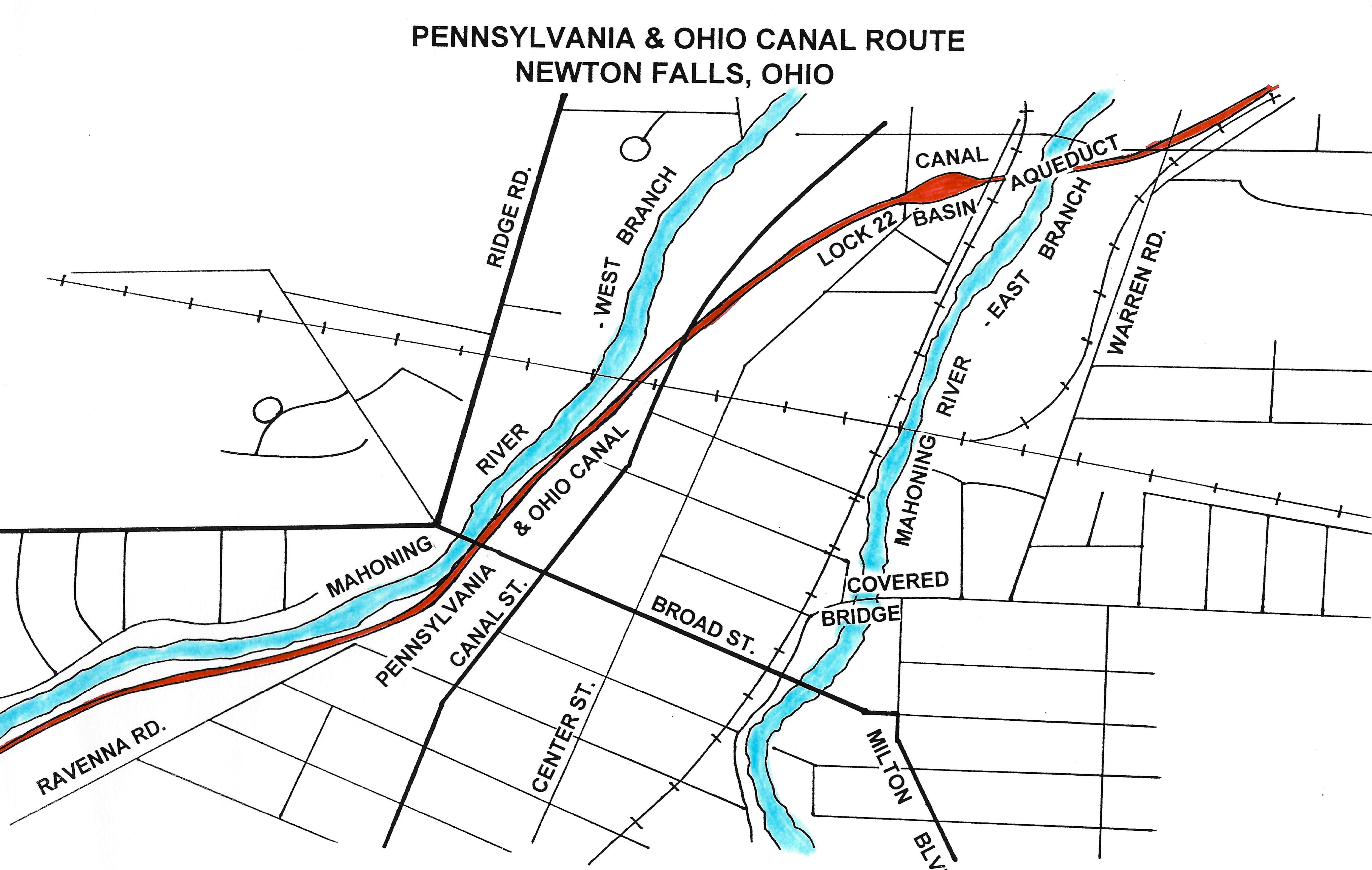
Locally, the canal entered the valley of the East Branch of the Mahoning River, going through Campbellsport, Newport, McClintocksburg, Newton Falls, and into Warren Township at the Center of the World. Toll offices were located at Youngstown, Warren, and Akron. Through Newton Township, the canal usually ran parallel to the Mahoning River, but it shared the river bed near the dam, a channel was dug just west of Lock Street eastward to the East Branch of the Mahoning River which it crossed via an aqueduct , and then another channel was cut for its journey into Warren Township.
The state legislature established certain standards for the building of its canals but left the actual construction to private companies. The average canal dimensions were 40' wide at the water line and 26' wide at the bottom bed. The water depth was a minimum of 4'. There was a 10' wide towpath along the edge of the channel for the mules or horse teams and on the opposite side of the canal a 5' wide berm. Remnants of the canal channel and towpath can still be seen in Newton Falls and the township. Frequently, the railroad bed overlaps the canal or home owners and businesses added fill dirt to cover the route. Traces are still evident in some backyards and farm fields particularly as one moves west closer to the Portage County line.
To overcome 424 feet of rise and fall in the terrain, the canal required 54 locks, 9 dams, and 2 major feeders for the Ravenna Summit level. The lock channels averaged 15' wide by 90' long for boats which were usually 14' by 80'. The locks were numbered westward in ascending order. Newton Falls Lock 22 was located off North Center and Lock streets, on property opposite R. W. Sidley, Inc. At that time, this section of Newton Falls was known as Earlesville and an 1840 map shows the existence of a basin on the east side of the lock. The basin was a widened portion of the canal where boats waited for loading and unloading or to enter the lock.
The stone masonry aqueduct over the East Branch of the Mahoning River may have been located just to the north of what is a railroad bridge today and was supported by three 50' spans which no longer exist. The stone was quarried locally along the river. The construction of an aqueduct over a river was considered to be one of the most difficult tasks in the building of the canal. Only one other aqueduct was constructed on this canal; it crossed the Shenango River in Pennsylvania at the Mahoning/Beaver junction. Of the 57 road bridges over the canal, five were in the Newton Falls area.
Three types of boats were used on the canal: passenger and cargo, packets, and freight boats. The boats were not designed for speed. Cargo boats were limited to 4 mph and packets were only permitted to move at 6 mph in order to prevent erosion of the canal banks. The flat-bottomed boats with pointed prows rode low in the less than 4' of water and could haul 50 - 80 tons of cargo.
A full crew of a freight boat was a captain, a steersman, a bowsman to help the lockmaster, and a mule driver. Boats were usually towed by three mules in tandem on a single tow line along a tow path followed by a boy driver. These boats had cargo areas and 3 small cabins for the captain and his family, the crew, and a spare mule.
Women began to travel the canal when packet boats were added. Packets carried 50 to 75 passengers, had curtains and dormitories, and often were pulled by horses throughout the night with larger crews. The P & O Canal was believed to have more packet travel than any other Ohio canal. The average fare was 2¢ per mile and the lucky ones who had bed sheets often found they were used the next day as tablecloths. Boats frequently changed names with new owners and paint. One boat constructed in Warren was named Trumbull and traveled this canal route for many years. President James A. Garfield worked on his cousin's Evening Star freight barge for two months as a sixteen-year-old in 1848. The last boat to use the canal was a freight barge called The Telegraph which was hauling limestone in 1872.
Typical freight from the Newton Falls area included woolen goods, plow handles, staves, barrels, lumber and farm products such as butter, cheese and grains. At least 3 large warehouses and mills for lumber, wool and grain were located along or near the canal route. In the mid-1800's, Newton Township was a thriving agricultural center and farmers usually processed their harvest in a form that preserved well rather than shipping the raw produce. The township was widely known for its excellent hardwood trees. Woolen blankets manufactured in a local mill even received the praise of Buffalo Bill. Toll rates of mils-per-ton were charged to ship freight on the canal.
Between 1850 and 1860, the canals began to lose ground to the railroads. The state had a debt of almost $17 million by 1849 for the internal improvements of the canal projects. The canals began to lose money as the railroad in Ohio eventually laid more track than any other state in the nation. The railroads could move people and freight faster all year round, if not always more cheaply. The canals had to shut down during winter months and stagnant water created health problems which made them undesirable neighbors. Frequently, the expanding railroads bought into the canals, contributed to their decline, and then purchased the land for their railroad beds.
As the canals lost revenue, they declined and the state did not receive full return on its investment. Since it was primarily funded with private capital, the Ohio & Pennsylvania Canal did not create that dilemma. It was the only canal which paid its debt to the investors even though this did not occur until 1903.
The Cleveland and Mahoning Railroad was completed in 1853 and bought control of the canal in 1854. The C & M Railroad sold the canal right-of-way to the Pittsburgh, Cleveland & Toledo Railroad in 1881. This became the Pittsburgh & Western Railroad in 1884 and was purchased by the Baltimore and Ohio Railroad or CSX as we know it today.
Sources:
Davis, Harold E. The Pennsylvania-Ohio Canal: 1823-1877. Hiram Historical Society, 1929.
Finn, Chester. The Ohio Canals: Public Enterprise On the Frontier. Ohio Historical Society, 1942.
Gieck, Jack. A Photo Album of the Canal Era: 1825-1913. Kent State University, 1988.
Woodward, Ella. History of Newton Falls. Woodward, 1942.